Andaman Island Location & Connectivity Guide
Everything you need to know about where Andaman Island sits within Penang — distances, travel times, road access, and the infrastructure developments that will shape the future.
15 min
To George Town
10 min
To Gurney Drive
35 min
To Airport
20 min
To Batu Ferringhi
Where Is Andaman Island in Penang?
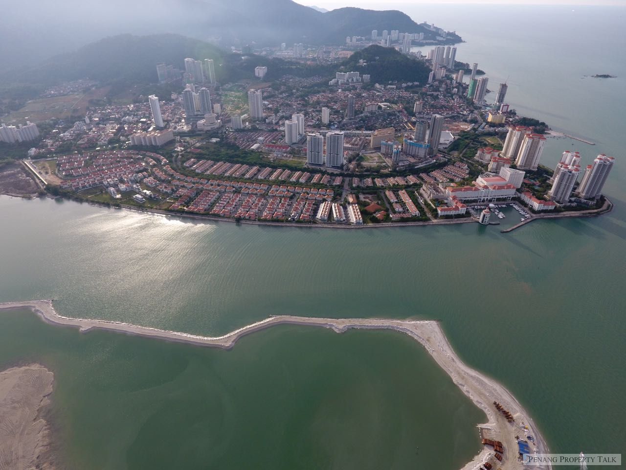
Andaman Island occupies a prime position on the northeast coast of Penang Island, within the Tanjung Tokong district. It is the centrepiece of the Seri Tanjung Pinang masterplan — a 240-acre waterfront township created through carefully planned land reclamation by Eastern & Oriental Berhad, one of Malaysia's most established property developers.
Despite the word "island" in its name, Andaman is seamlessly connected to the Penang Island road network. There are no bridges to cross, no ferries to catch. The reclaimed land extension connects directly to Jalan Tanjung Tokong, one of the island's primary arterial roads, via Jalan Seri Tanjung Pinang. This means residents enjoy the exclusivity and waterfront setting of island living with the full convenience of road-connected accessibility.
Geographically, Andaman Island is positioned between the established residential suburb of Tanjung Tokong to the south and the beachfront area of Tanjung Bungah to the north. To the east lies the Straits of Malacca, providing residents with panoramic sea views towards the mainland and Kedah Peak. To the west, the lush hills of Penang's central spine form a dramatic green backdrop.
Distances & Travel Times from Andaman Island
One of Andaman Island's greatest advantages is its connectivity. Despite offering a resort-style waterfront setting, it is remarkably close to all of Penang's key destinations. The following table provides accurate travel times based on normal traffic conditions.
| Destination | Distance | Drive Time (Off-Peak) | Drive Time (Peak) | Route |
|---|---|---|---|---|
| George Town (UNESCO zone) | 8 km | 15 min | 25 min | Jalan Tanjung Tokong → Jalan Burma |
| Gurney Drive | 5 km | 10 min | 18 min | Jalan Tanjung Tokong direct |
| Gurney Plaza / Paragon | 5.5 km | 10 min | 18 min | Jalan Tanjung Tokong direct |
| Penang International Airport | 22 km | 35 min | 45 min | LCE Expressway |
| Butterworth (Mainland) | 16 km | 30 min | 40 min | Penang Bridge |
| Batu Ferringhi | 10 km | 20 min | 25 min | Jalan Tanjung Bungah coastal road |
| Komtar (George Town CBD) | 9 km | 18 min | 28 min | Jalan Tanjung Tokong → Jalan Burma |
| Penang Bridge | 14 km | 25 min | 35 min | LCE Expressway |
| Second Penang Bridge | 25 km | 35 min | 50 min | LCE Expressway → Bayan Lepas |
| Queensbay Mall | 15 km | 25 min | 35 min | LCE Expressway → Bayan Lepas |
| Dalat International School | 2.5 km | 5 min | 8 min | Local roads |
| Straits International School | 3.5 km | 10 min | 12 min | Seri Tanjung Pinang internal |
| Gleneagles Penang | 7 km | 15 min | 22 min | Jalan Tanjung Tokong → Jalan Pangkor |
| Island Hospital | 6 km | 12 min | 20 min | Jalan Tanjung Tokong → Jalan Burma |
* Drive times are estimates based on Google Maps data and may vary depending on traffic conditions, time of day, and route chosen. Peak hours are typically 7:30–9:00 a.m. and 5:30–7:30 p.m. on weekdays.
Road Access & Driving Routes
Andaman Island benefits from excellent road connectivity, with multiple routes connecting it to Penang's major destinations. Understanding these routes helps residents and visitors plan their journeys efficiently.
Primary Route: Jalan Tanjung Tokong
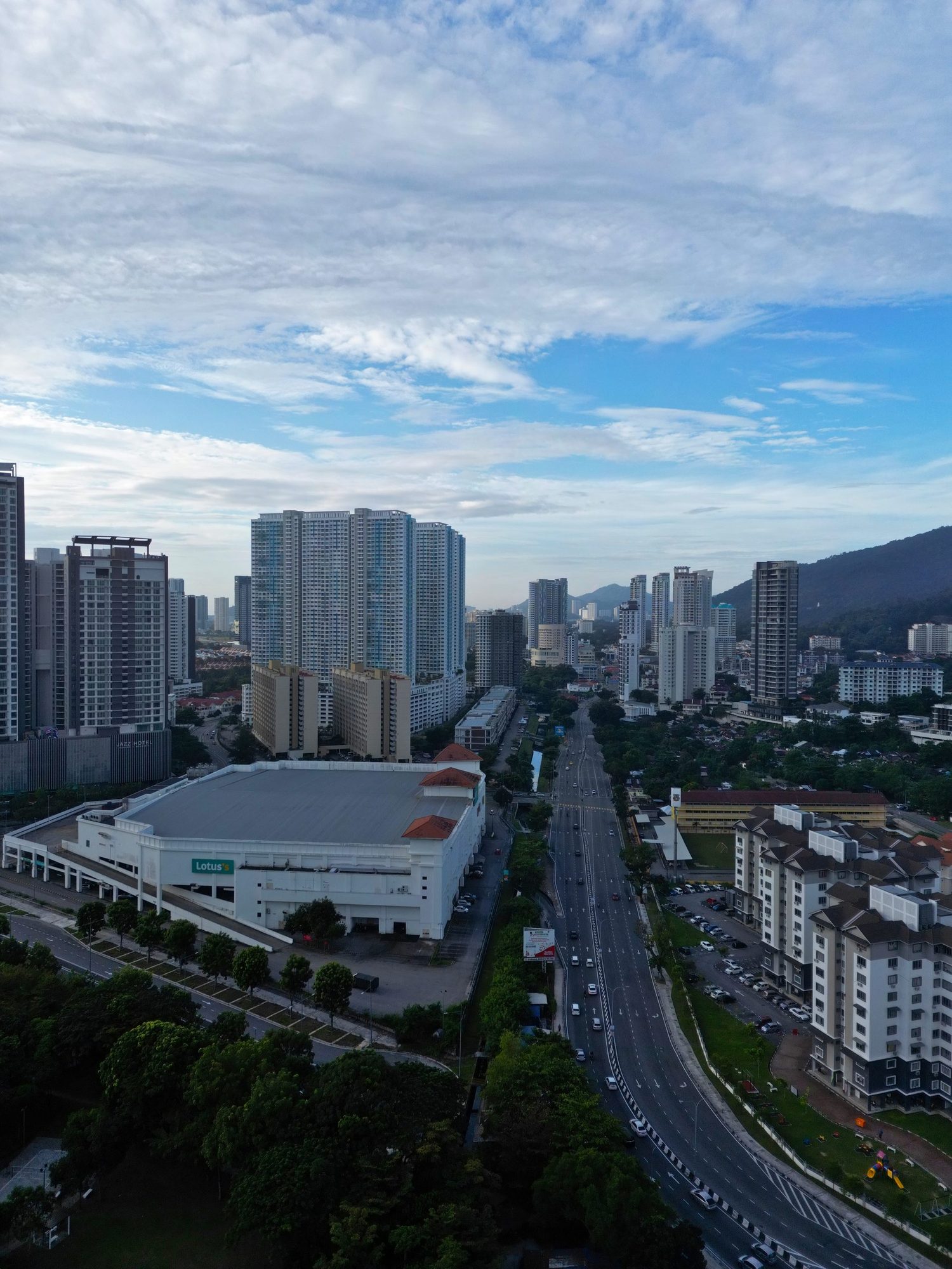
Jalan Tanjung Tokong is the main arterial road serving Andaman Island. This well-maintained dual carriageway runs along the northeast coast of Penang Island, connecting Tanjung Tokong to Gurney Drive in the south and Tanjung Bungah in the north. It provides direct access to George Town, and traffic flow is generally smooth outside of rush hour peaks. The road is well-lit, with pedestrian crossings and dedicated turn lanes at major junctions.
Expressway Access: Tun Dr Lim Chong Eu Expressway
For longer journeys — particularly to the airport, Penang Bridge, and southern Penang — the Tun Dr Lim Chong Eu Expressway (LCE) is the fastest route. Accessible from Jalan Tanjung Tokong via the Gurney Drive interchange, the LCE is a limited-access expressway that bypasses George Town's city centre entirely. This route cuts travel time to the airport to approximately 35 minutes and provides the most efficient connection to the Penang Bridge and Second Penang Bridge.
Coastal Route: To Batu Ferringhi & the North
Heading north from Andaman Island, the coastal road winds through Tanjung Bungah before reaching Batu Ferringhi — Penang's best-known beach resort area — in approximately 20 minutes. This scenic route hugs the coastline, passing through the fishing villages and beachfront developments that characterise Penang's northern shore. Beyond Batu Ferringhi, the road continues to Teluk Bahang and the entrance to Penang National Park.
Internal Roads: Seri Tanjung Pinang
Within the Seri Tanjung Pinang masterplan, roads are designed to a township standard with wide carriageways, landscaped medians, dedicated pedestrian and cycling paths, and efficient traffic management. Multiple access points from Jalan Tanjung Tokong prevent bottleneck congestion. The internal road network is well-signed and maintained by the township's estate management team.

Public Transport & Ride-Hailing
While most Andaman Island residents drive or use ride-hailing services, the area is reasonably well-served by public transport, with improvements on the horizon as part of the Penang Transport Master Plan.
Rapid Penang Bus Services
Rapid Penang operates several bus routes along Jalan Tanjung Tokong. Route 101 connects Tanjung Tokong to Komtar (George Town's central transit hub) via Gurney Drive, running at 15–20 minute intervals during peak hours. Route 102 extends the service northward to Batu Ferringhi and Teluk Bahang. Bus fares are subsidised, typically RM 1.40–2.70 per trip. Bus stops are located along Jalan Tanjung Tokong within walking distance of the Seri Tanjung Pinang entrance.
Grab & Ride-Hailing
Grab is the dominant ride-hailing platform in Penang and is widely used by Andaman Island residents. Service availability is excellent — pickups are typically within 3–5 minutes. Representative fares from Andaman Island include: George Town RM 8–15, Gurney Drive RM 6–10, airport RM 35–50, Batu Ferringhi RM 15–22. GrabCar Premium is also available for those preferring newer or larger vehicles.
Airport Transfer Options
For airport transfers, residents typically use Grab (RM 35–50), private car services arranged through hotel or condominium concierge (RM 60–80), or pre-booked airport transfer services. Budget-conscious travellers can take the Rapid Penang Airport Express bus from Komtar to the airport (RM 2.70), though this requires a transfer at Komtar from the Tanjung Tokong bus service.
Infrastructure Developments & Future Connectivity
Andaman Island's already-excellent connectivity is set to improve further through several major infrastructure projects currently in various stages of planning and execution. These developments will enhance both daily convenience and long-term property values.
Penang LRT (Proposed)
The Penang Transport Master Plan (PTMP) includes a light rail transit system that, once completed, would significantly transform public transport across the island. The proposed alignment includes a station serving the Tanjung Tokong corridor, which would place Andaman Island residents within walking or short shuttle distance of a modern rail connection to George Town, Bayan Lepas, and the airport. While the exact timeline remains subject to federal approval and funding, the project represents a transformative long-term improvement in connectivity.
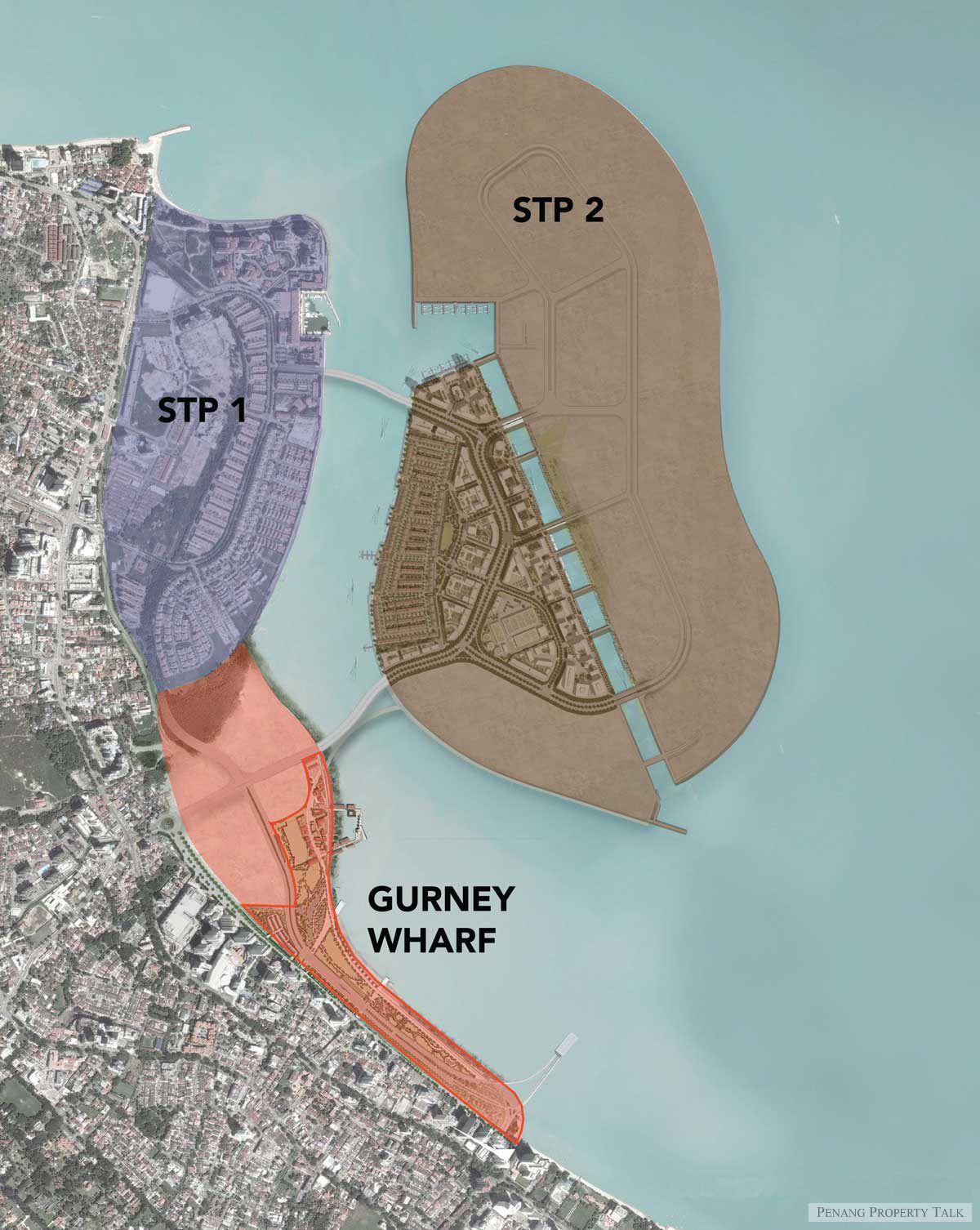
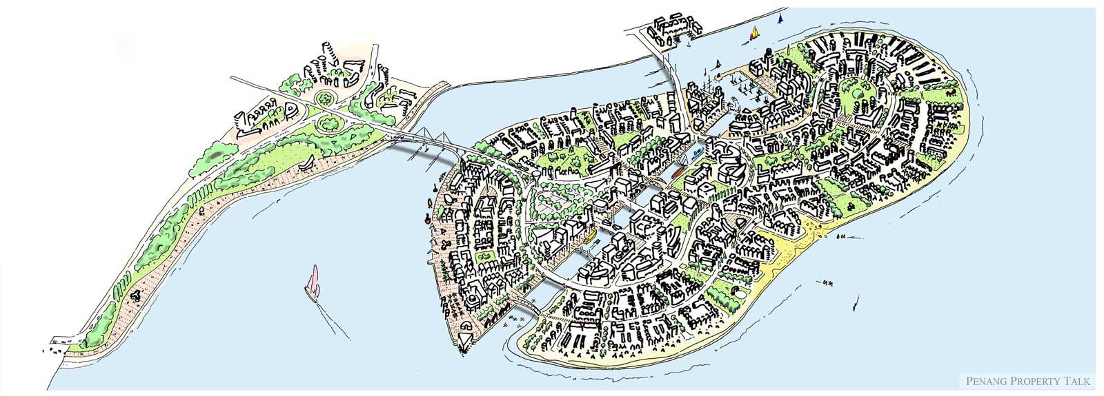
Seri Tanjung Pinang Phase 2
E&O's Seri Tanjung Pinang Phase 2 (STP2) is an approximately 253-acre extension of the existing masterplan. This massive development will add new residential precincts, commercial areas, public parks, a seafront promenade extension, and improved road connections. For existing Andaman Island residents, STP2 will enhance the neighbourhood with additional retail options, community facilities, and public spaces — all without disrupting the established character of the existing precinct.
Penang International Airport Expansion
The ongoing Penang International Airport expansion, targeted for completion by 2028, will increase the airport's capacity from 6.5 million to 12 million passengers annually. New international routes — including direct flights to Osaka, Seoul, and additional Chinese cities — will enhance connectivity for Andaman Island's cosmopolitan resident base. The expansion also includes a new terminal building, expanded runway capacity, and improved ground transport connections.
Road Network Improvements
The Penang state government has allocated funding for traffic improvements along the Tanjung Tokong corridor, including junction upgrades, signal optimisation, and potential road widening at known bottleneck points. These improvements aim to reduce peak-hour congestion and improve traffic flow between Tanjung Tokong, Gurney Drive, and the expressway interchange. Smart traffic management systems using real-time data are also being piloted in the area.
The Seri Tanjung Pinang Masterplan
Understanding Andaman Island's location requires understanding the Seri Tanjung Pinang (STP) masterplan within which it sits. Launched by Eastern & Oriental Berhad in the early 2000s, STP is Penang's most ambitious integrated waterfront development — a carefully planned township that has fundamentally redefined what coastal living means on the island.
The Phase 1 masterplan covers approximately 240 acres of reclaimed land, incorporating residential developments across multiple price points, the Straits Quay marina and retail complex, international schools, landscaped parks, a waterfront promenade, and comprehensive infrastructure including roads, utilities, and stormwater management. Unlike many development projects that prioritise density, STP maintains generous setbacks, wide roads, and abundant green space, creating a genuine township environment rather than a cluster of isolated towers.
E&O's track record in estate management is a critical differentiator. Long after individual buildings are completed and handed over, the township's common areas — roads, parks, promenades, security systems — continue to be maintained to a consistently high standard. This ongoing commitment to upkeep is reflected in property values: STP developments have shown steady appreciation over the past decade, consistently outperforming the broader Penang market.
TheLume at Andaman is the latest landmark within the STP masterplan — a 49-storey freehold tower of 261 residences that represents the premium tier of the township. For more on the neighbourhood's amenities and lifestyle, explore our Tanjung Tokong Neighbourhood Guide.
Frequently Asked Questions About Andaman Island's Location
Practical answers to the most common questions about getting to and around Andaman Island, Penang.
Visit Andaman Island — Book a Sales Gallery Tour
See the location for yourself. Book a private tour of TheLume's sales gallery and show units on Andaman Island.
Related Guides
Andaman Penang Living Guide
Daily life, expat community, and lifestyle on Andaman Island, Penang.
Andaman vs Batu Ferringhi
Compare the two premier coastal living options in northwest Penang.
Where the Rich Live in Penang
Penang's most exclusive residential enclaves and what makes them sought-after.
Book a Viewing
Schedule a private tour of TheLume show units and experience Andaman firsthand.